Read the statement by Michael Teeuw here.
MMM-aviationwx (Aviation weather)
-
Ok, time for testing. Both of these modules are using aviationweather.gov for reasons explained above. I will learn how to make multiple requests within the module and move to avwx.rest/api, eventually.
Most like original in appearance and does allow for international ICAO’s.
https://github.com/mykle1/MMM-Pilot{ disabled: false, module: "MMM-Pilot", position: "top_left", config: { ICAO: "KJFK,EGLL,UUDD,EDDT,RJAA,ZBAA,LFPG,LIRF", // Any 8 International ICAO's colorCode: "Alternative", // Standard or Alternative updateInterval: 10 * 60 * 1000, useHeader: false, header: "", maxWidth: "400px", } }, -
A new spin on the display and does allow for international ICAO’s.
https://github.com/mykle1/MMM-WISP{ disabled: false, module: "MMM-WISP", position: "bottom_bar", // you could try top_bar and thirds config: { ICAO: "KJFK,EGLL,UUDD,EDDT,RJAA,ZBAA,LFPG,LIRF", // Not limited to 8 International ICAO's colorCode: "Alternative", // Standard or Alternative useHeader: false, header: "", maxWidth: "100%", } }, -
Thanks for your work on this!
I just installed Magic Mirror and started looking around for an aviation weather module that included Alaska. I just now stumbled on this thread, and see that your work should include the airports that I want in my list. I’ll install and test it as soon as I get a chance.
-
@Area-49 said in MMM-aviationwx (Aviation weather):
I’ll install and test it as soon as I get a chance.
Great! Let me know how things go. Use the four letter ICAO for each station you want to see
-
Looks like there is a dependency required - from my PM2 error log file: Error: Cannot find module ‘xml2js’
I’m just getting started figuring out Linux, Git repository, and Javascript, so I’m not sure where to find - and under what directory to install this dependency.
Is this the one to install? https://github.com/Leonidas-from-XIV/node-xml2js
Thanks
-
This post is deleted! -
You have to run
npm installin the MagicMirror/modules/MMM-(THE MODULE NAME) folderI don’t know which one of the two you are trying
So for MMM-Pilot it’s
npm installin the MagicMirror/modules/MMM-Pilot directoryAnd for MMM-WISP it’s
npm installin the MagicMirror/modules/MMM-WISP directory -
@Area-49 said in MMM-aviationwx (Aviation weather):
I’m just getting started figuring out Linux, Git repository, and Javascript, so I’m not sure where to find - and under what directory to install this dependency.
Sorry about the lack of directions. I only just put this up for testing so it hasn’t been officially released or properly documented.
-
Mykle1,
Got it to install & run. Thanks for the clarification on how to install.
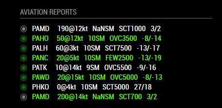
I put in my chosen airports in AK (also one in HI - just so I can feel bad about how cold it is here right now!)
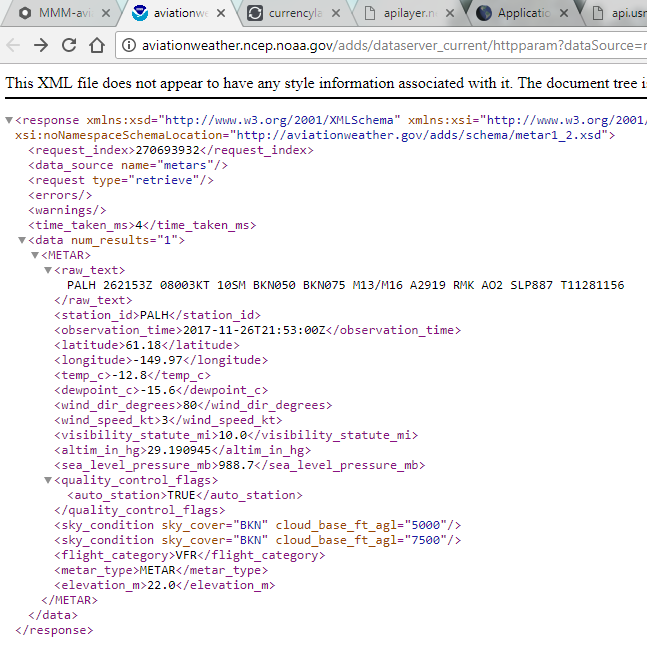
Not sure if you know, but you can return only the most recent Metar data from each airport by using a slightly different URL and the following format:
http://aviationweather.ncep.noaa.gov/adds/dataserver_current/httpparam?dataSource=metars&requestType=retrieve&format=xml&hoursBeforeNow=4&mostRecent=true&stationString=PALHI like the output format. I think it works well for at-a-glance information purposes. However if I had a choice, I’d like a config option for temperature and dew point units. I’m used to looking at these in Fahrenheit. I have my own simple personal website where I link to a few Metar reports directly, and the pages show both the raw units and (converted).
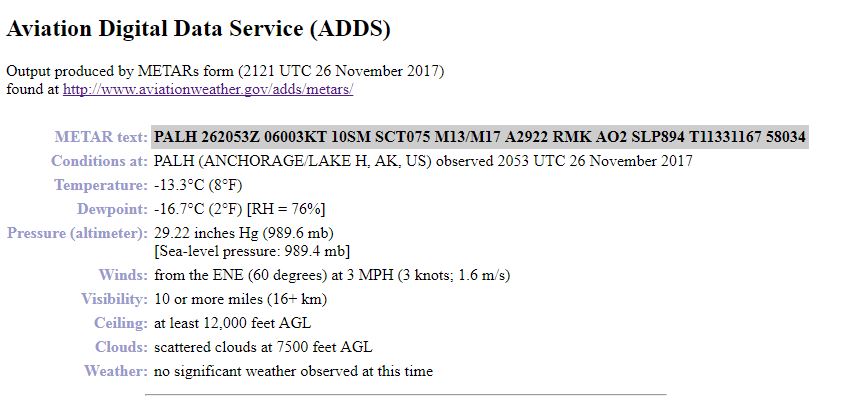
Example for PALH (Lake Hood AK): http://www.aviationweather.gov/adds/metars/?station_ids=palh&std_trans=translated&chk_metars=on&hoursStr=most+recent+only&submitmet=Submit
Not a huge deal on the units, but maybe put it on the wishlist?
Thanks again for your effort on putting this together!
-
@Area-49 said in MMM-aviationwx (Aviation weather):
Not a huge deal on the units, but maybe put it on the wishlist?
Sure, I’ll keep that in mind. I’m not in a rush after 500+ lines of code already. :-)
Thanks again for your effort on putting this together!
You’re welcome. It’s nice to be appreciated. :-)
Now, the first url you posted is great. If you can edit it to pull multiple ICAO’s at once, then I’ll use it. I tried briefly. It only seems to return 1 ICAO. The url I’m using pulls observations from the last hour.
The second url you posted is also great. However, it doesn’t get me to the xml data that I need for the module. If you can manage to get a url to return the very same data like this, we’ll be jamming