Read the statement by Michael Teeuw here.
MMM-aviationwx (Aviation weather)
-
So, it just dawned on me that the Raw-Report data looks pretty much like what I’ve been trying to achieve piece by piece, according to all of the wishes in this topic, aside from the order and the formatting. Shrug
Raw-Report: UUDD 220230Z 32003MPS 9999 OVC014 00/M02 Q1005 R32L/520295 NOSIG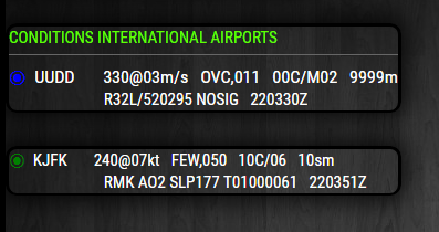
Anyway, the flight rules have been converted to alternative color coding and are working. I can add the standard color coding at another time, via config option, so you can choose one or the other. The units will also will come from the data. The only time coming from the data is in Zulu time. It does not say if that is the time of the report.
Do you want a second line of data? Would you rather a single line as you’ve shown above?
Most importantly:
Someone needs to figure out how to call multiple ICAO’s in a single request. This would make my job a whole lot easier. Do I have to do everything? ;-)
@allebone said:
This is amazing collaboration.
So, collaborate already! ;-)
https://avwx.rest/api/metar/uudd only gets data for a single ICAO, uudd.
EDIT
I contacted the API. Only one station per request. Of course! I’ll think of something. -
Here we encounter another problem with the “Remarks” line. It is not always the same length. When it is longer it wraps and looks messy. I could trim the data but that defeats the purpose. How set are we with having the remarks line?
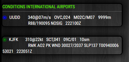
-
Standard and Alternative color coding is now a config option
-
So, I keep flip-flopping with API’s. I’m not thrilled with
aviationweather.govbut it does allow me to call multiple international stations in one request. However, there are differences in what each API offers. Until I can figure out how to make multiple requests toavwx.rest/apithen this will have to do. When I do figure that out I intend to use theavwx.rest/apiCaveat
You can enter up to 8 international station ICAO’s. However, only stations with observation times within the last hour will be displayed. For instance, if KJFK has 2 observations within the last hour, then both observations will be displayed if there is an older observation among your other stations. In any case, the stations will order themselves by observation time starting with the most recent at the top.
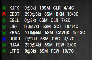
Question: Remove the kt from wind speed? This API only provides kt.
Question: Remove the C from temperature? This API only provides C
Question: Any desire to have this module occupy the bottom or top bar where each station (one at a time) will span the entire width of your display? Ex, below the newsfeed module. I’m thinking a single line that can contain ALL of the data (raw data included) and you choose the amount of time each is displayed. Just a thought.
-
I’d be surprised if the gov api is converting reported units to kts… I can have a look at this later and see if that’s really the case, or if it’s just providing values.
C can go as all temps are reported in celcius, that’s the only bit that I think is common!!
Have you tried emailing the guy at avwx?
He might be able to help
-
@stephenmelody said in MMM-aviationwx (Aviation weather):
Have you tried emailing the guy at avwx?
I did. That’s how I know I can’t use a single url for multiple stations (as in aviationweather). It’s my own lack of coding capability that prevents me from making multiple calls to that API from within the module. Help with that will have to come from this forum or somewhere else, not the API.
I’d be surprised if the gov api is converting reported units to kts
The data says,
wind_speed_kt -
“C” removed
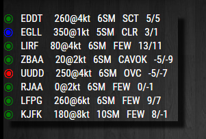
Individual coloring of each line made easy for easier viewing.
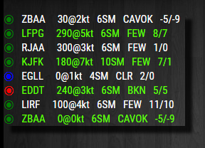
Still trying to work out the problem with
/avwx.rest/api -
@Mykle1 said in MMM-aviationwx (Aviation weather):
Hi again,
Sorry for my long absence, I had really tough week of flights,and now I’m have 1 day off ;) Seem that you made a very good job with new module and I have seen that some questions were in place. So, just some of my opinions on these questions:
-
Remove C from temperature? - yes, indeed. We just need to be sure that all data in C.
-
Remove the kt from wind speed? The best way to keep initial units of measure (m/s in RU, kts in other contries from example). But, as I undestood, thats depends on API…
-
About remarks: first, just to recall - best way to have them to be configurable (to have options to display them/not display them at all). And for me - best way to keep the whole RMK field. Is there any possibility to align it by the next way:
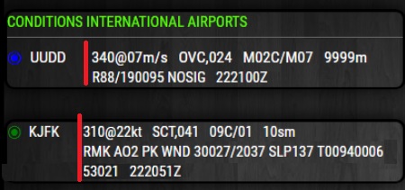 ?
? -
Also, I would ask you to keep digits after OVC/FEW/etc - it’s a important information, which means a top of clouds. I’ve just seen that on the last screenshoots this information is missing.
If you have any additional questions - please, let me know.
And thanks you again for your job. -
-
-
@320fan said in MMM-aviationwx (Aviation weather):
About remarks: first, just to recall - best way to have them to be configurable (to have options to display them/not display them at all). And for me - best way to keep the whole RMK field.
I think, in the interest of mirror real estate, I will leave out the raw data for now. IMHO, an MM module is not meant to occupy all, or much of the display, as an iPad app would do.
Is there any possibility to align it by the next way:
I am not using a table in the module (I don’t know how) so alignment is tricky. I’m doing the best I can.
Also, I would ask you to keep digits after OVC/FEW/etc - it’s a important information, which means a top of clouds. I’ve just seen that on the last screenshoots this information is missing.
Agreed, and it will remain, as long as the data provides it.
Eventually, I’ll learn how to make multiples calls within the module. Then I can use the API of choice. For now I am battling with xml data of aviationweather.gov
