MagicMirror Forum
    • Recent
    • Tags
    • Unsolved
    • Solved
    • MagicMirror² Repository
    • Documentation
    • 3rd-Party-Modules
    • Donate
    • Discord
    • Register
    • Login
    A New Chapter for MagicMirror: The Community Takes the Lead
    Read the statement by Michael Teeuw here.

    MMM-RAIN-MAP (new: version 2.x)

    Scheduled Pinned Locked Moved Utilities
    193 Posts 39 Posters 321.3k Views 42 Watching
    Loading More Posts
    • Oldest to Newest
    • Newest to Oldest
    • Most Votes
    Reply
    • Reply as topic
    Log in to reply
    This topic has been deleted. Only users with topic management privileges can see it.
    • H
      hogedir
      last edited by

      @Jalibu it’s simply a raspi 4B 8GB, with a normal installation of MMM. I don’t know if i need to open a bug, it’s just the dump of the map that doesn’t work as you see on the screen.

      A question : Your module accept FRENCH locations no for the rain map ?

      Your module works well here, it’s only the map that is not get.

      I don’t have any blocker in the dns. so I don’t undertand because all the other modules works fine, except of that map dump.

      Here is my config.js :

      {
      module: “MMM-RAIN-MAP”,
      position: “top_center”,
      config: {
      animationSpeedMs: 400,
      colorScheme: 2,
      colorizeTime: true,
      defaultZoomLevel: 8,
      displayTime: true,
      displayTimeline: true,
      displayClockSymbol: true,
      displayHoursBeforeRain: -1,
      extraDelayLastFrameMs: 1000,
      extraDelayCurrentFrameMs: 3000,
      // markers: [
      // { lat: 49.41, lng: 8.717, color: “red” },
      // { lat: 48.856, lng: 2.35, color: “green” },
      // ],
      // mapPositions: [
      // { lat: 8.717, lng: -2.725, zoom: 9, loops: 1 },
      // { lat: 8.717, lng: -2.725, zoom: 6, loops: 2 },
      // { lat: 48.856, lng: 2.35, zoom: 6, loops: 1 },
      // { lat: 48.856, lng: 2.35, zoom: 9, loops: 2 },
      // { lat: 49.15, lng: 6.154, zoom: 5, loops: 2 },
      // ],
      // mapUrl: “https://a.tile.openstreetmap.de/48.2649/{x}/{y}.png”,
      mapUrl: “https://a.tile.openstreetmap.de/#map=8/48.471/-2.725”,
      // mapUrl: “https://tiles.wmflabs.org/bw-mapnik/8/48.471/-2.725”,
      mapHeight: “420px”, // must be a pixel value (no percent)
      mapWidth: “420px”, // must be a pixel value (no percent)
      maxHistoryFrames: -1,
      maxForecastFrames: -1,
      substitudeModules: [],
      updateIntervalInSeconds: 300,
      }
      },

      JalibuJ 1 Reply Last reply
      Reply Quote 0
      • JalibuJ
        Jalibu Module Developer @hogedir
        last edited by Jalibu

        @hogedir your configuration is buggy. Please read the module’s Readme.
        You don’t have to (and should not) change the mapUrl at all.
        Use mapPositions to justify it. The module should work world-wide.
        I’d recommend to use the default values whenever possible and just to set values you need to override.

        Does that work for you?

        {
         module: "MMM-RAIN-MAP",
         position: "top_center",
         config: {
          mapPositions: [
           { lat: 48.472, lng: -2.725 }    
          ]
         }
        }
        
        H 1 Reply Last reply
        Reply Quote 0
        • H
          hogedir @Jalibu
          last edited by

          @Jalibu Thanks. I copied your code, and nothing again. No map.
          f701d2bd-9f62-42b3-9922-eab8b1a5702a-image.png

          S JalibuJ 2 Replies Last reply
          Reply Quote 0
          • S
            sdetweil @hogedir
            last edited by

            @hogedir can you show the messages at mm startup?

            either npm start or if you use pm2, then

            pm2 logs --lines=50

            Sam

            How to add modules

            learning how to use browser developers window for css changes

            1 Reply Last reply
            Reply Quote 0
            • JalibuJ
              Jalibu Module Developer @hogedir
              last edited by

              @hogedir I noticed there were wrong double quote characters in the code of my last post.
              Please try again with the code below. Otherwise, please open an issue on GitHub and provide all the information asked in the form (entire config & logs)

              {
               module: "MMM-RAIN-MAP",
               position: "top_center",
               config: {
                mapPositions: [
                 { lat: 48.472, lng: -2.725 }    
                ]
               }
              }
              
              H 1 Reply Last reply
              Reply Quote 0
              • H
                hogedir
                last edited by hogedir

                @hogedir @Jalibu it’s working now Thanks ! : the map is showing well now BUT the rain is not showed very well !

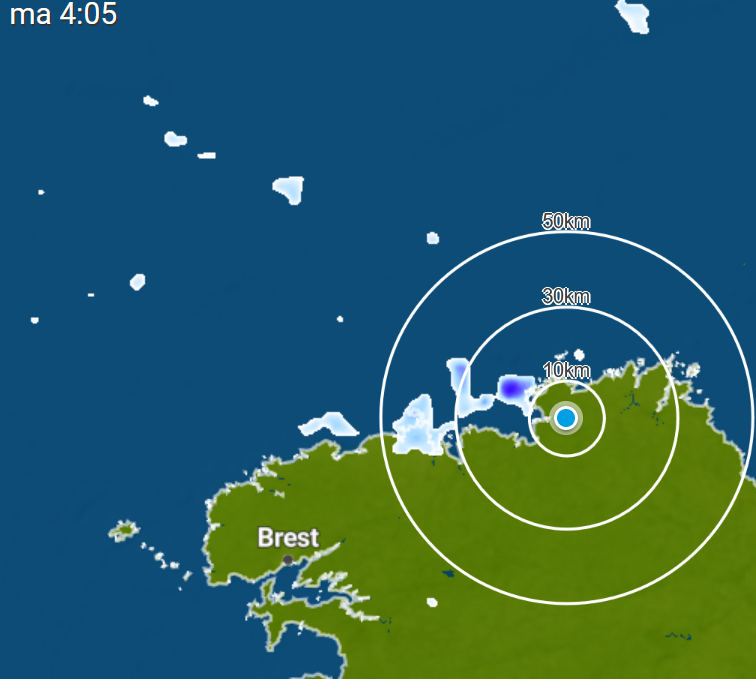
                I compared what i see outside of my home and we had 5minutes before some rain and your data flow is not precise at all, i did not saw a rain in my region on your map but i saw it in weatherplaza.

                I give you the page which is more precise and realistic than the rain data you have in the module : https://www.weerplaza.nl/regenradar/europa/frankrijk/

                Map of rains with weather plaza : :
                fdac3039-d82d-4f7c-bedf-b7d959e375fc-image.png

                Map of rains with your module : :

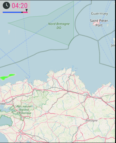
                de450518-6d5d-4101-8ea5-4a2a2f1c0265-image.png

                Lots of difference, weather plaza is realistic (i checked outside 2 times yesterday, your module did not show well the rain.)

                • Second thing, I noticed something too : i want the “pause” time before the red zone to be more fast (some mms more fast). is it possible to change the “pause timer” ? Thanks
                1 Reply Last reply
                Reply Quote 1
                • H
                  hogedir @Jalibu
                  last edited by hogedir

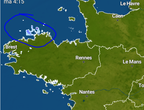
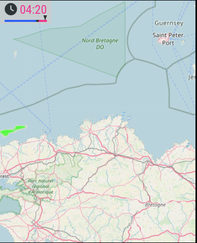
                  @Jalibu Look Here is the map of Weatherplaza (meteoplaza) in the same time than yours, if it can help.
                  3a971133-4157-43ea-8012-e5a259516b48-image.png

                  and then the data flow on the module (less rain and less precise) :
                  d6608816-5d56-42be-bff5-4b551658c684-image.png

                  thanks

                  S 1 Reply Last reply
                  Reply Quote 0
                  • S
                    sdetweil @hogedir
                    last edited by

                    @hogedir it’s not ‘his’ data. he is requesting a graphic from a service, and displaying what they give.

                    Sam

                    How to add modules

                    learning how to use browser developers window for css changes

                    H 2 Replies Last reply
                    Reply Quote 0
                    • H
                      hogedir @sdetweil
                      last edited by

                      This post is deleted!
                      1 Reply Last reply
                      Reply Quote 1
                      • H
                        hogedir @sdetweil
                        last edited by hogedir

                        @sdetweil @Jalibu Obiviously !

                        I mean it’s Rainviewer data but rainviewer is not 100% legit.

                        weerplaza is the best radar information worldwide. They use sevral radar information worldwide and unite all these data for free. I think the only one very precise to offer this type of information.

                        They have a widget API too ! you could integrate in addition to Openweather+rainviewer.

                        The weerplaza api is here : https://www.weerplaza.nl/weerwidgets/

                        And @Jalibu Thanks for your work, I like the zoom option and the ultimate option you added and it’s very useful.

                        1 Reply Last reply
                        Reply Quote 0
                        • M
                          MajorC Project Sponsor
                          last edited by

                          I have also often had the feeling that Rainviewer’s data is not particularly accurate.
                          If the option to switch to another provider were to be built in, I could only welcome that.

                          JalibuJ 1 Reply Last reply
                          Reply Quote 0
                          • JalibuJ
                            Jalibu Module Developer @MajorC
                            last edited by

                            @MajorC @hogedir
                            Unfortunately, Weerplaza.nl does not offer an API. I can’t just take their weather data and use it in MMM-RAIN-MAP.
                            They only allow to embed their service as an iFrame. You can easily do this on your own with https://github.com/alberttwong/MMM-iFrame

                            H 1 Reply Last reply
                            Reply Quote 0
                            • H
                              hogedir @Jalibu
                              last edited by hogedir

                              @Jalibu Is it possible to add a second source possible to be selected in the module ? the goal could be to show CLOUDS via SATELLITE RADAR too. Using IFRAME is not a solution. I prefer to use a unique MAP with rain + clouds included.

                              because lots of people needs to know if some clouds will be showed

                              Could be very very a master class module with that option.

                              here an example of sat clouds : http://en.sat24.com/en

                              Here the code you could use to integrate that data in the module : http://en.sat24.com/en/freeimages

                              RAINVIEWER DATA is not accurate at all like said MajorC(Project Sponsor). It doesn’t represent the reality.

                              Check

                              JalibuJ 1 Reply Last reply
                              Reply Quote 0
                              • JalibuJ
                                Jalibu Module Developer @hogedir
                                last edited by

                                @hogedir I understand the need and desire. However, neither the weather data/layers from Weerplaza.nl, nor those from sat24.com are in any way compatible with the previous module. It is technically not so easy to put their layers just “over” the map ;-)
                                If someone finds a solution and takes care of the programming, then I would be happy to put this extension into the module.
                                However, I don’t have the time to take care of it myself.

                                1 Reply Last reply
                                Reply Quote 0
                                • W
                                  whimsicality
                                  last edited by

                                  Is there a basic resource on how to generate maps? I am struggling with this basic concept. I’ve been to open street maps but I don’t see any way to generate a file like you did in the example.

                                  S 1 Reply Last reply
                                  Reply Quote 0
                                  • S
                                    sdetweil @whimsicality
                                    last edited by

                                    @whimsicality the api provides the drawing of the maps

                                    Sam

                                    How to add modules

                                    learning how to use browser developers window for css changes

                                    W 1 Reply Last reply
                                    Reply Quote 0
                                    • W
                                      whimsicality @sdetweil
                                      last edited by

                                      @sdetweil according tot he config it looks like I’m supposed to input all kinds of GPS coordinates for the edges of the map as well as the link to the picture of the map… I think I’m just confused.

                                      S 1 Reply Last reply
                                      Reply Quote 0
                                      • S
                                        sdetweil @whimsicality
                                        last edited by sdetweil

                                        @whimsicality he’s telling the api the size and shape of the map to draw… because thats what they do…

                                        I do the same thing with chartjs… I tell it the size and shape and all the points in the data, and what kind of chart to draw, and it generates the graphics.

                                        Sam

                                        How to add modules

                                        learning how to use browser developers window for css changes

                                        W 1 Reply Last reply
                                        Reply Quote 0
                                        • W
                                          whimsicality @sdetweil
                                          last edited by

                                          @sdetweil I think I was making it unnecessarily complicated, I understand it now. thanks!

                                          1 Reply Last reply
                                          Reply Quote 0
                                          • W
                                            whimsicality
                                            last edited by

                                            hi! love this app but am struggling. I’ve tried the CSS mentioned here to change the opacity as well as just changing it under “config” but I can’t get teh opacity of the map to change. is there any other option to attempt?

                                            1 Reply Last reply
                                            Reply Quote 0

                                            Hello! It looks like you're interested in this conversation, but you don't have an account yet.

                                            Getting fed up of having to scroll through the same posts each visit? When you register for an account, you'll always come back to exactly where you were before, and choose to be notified of new replies (either via email, or push notification). You'll also be able to save bookmarks and upvote posts to show your appreciation to other community members.

                                            With your input, this post could be even better 💗

                                            Register Login

                                            • 1
                                            • 2
                                            • 6
                                            • 7
                                            • 8
                                            • 9
                                            • 10
                                            • 9 / 10
                                            • First post
                                              Last post
                                            Enjoying MagicMirror? Please consider a donation!
                                            MagicMirror created by Michael Teeuw.
                                            Forum managed by Sam, technical setup by Karsten.
                                            This forum is using NodeBB as its core | Contributors
                                            Contact | Privacy Policy