Read the statement by Michael Teeuw here.
MMM-aviationwx (Aviation weather)
-
@allebone - what colour scheme do you use for IFR/VFR/MVFR/LIFR? Personally I prefer the alternative one that I have called out above.
@Mykle1 - no problem, always here to make life harder :-D
Here’s another option that might be of interest, as it’s JSON format…
https://www.icao.int/safety/iStars/Pages/API-Data-Service.aspx
-
This would give you the NOTAM information…
https://www.npmjs.com/package/notamsMETAR / TAF:
https://www.npmjs.com/package/metar-tafhttps://www.npmjs.com/package/metar-js
Don’t know if they help…?
-
@stephenmelody said in MMM-aviationwx (Aviation weather):
Alternative: VFR-Green MVFR-Blue IFR-Red LIFR-Magenta Unknown-Grey
Would the text coloured per the rules work the same as a coloured circle? Yes - although a circle would be better for screen real estate I would imagine…Ok, I’ve coded the “Alterative” color scheme just now, as you’ve described it, using generic colors. You will get the corresponding colored circle depending on the Flight Rule. What I would like from you are HEX color codes for those five colors that work best against the black background. For instance, you may want a lighter blue as the generic blue is a little hard to see. Agreed?
-
I would like #FCDFFF, #FAAFBA, #E45E9D, #FFFF00 and #87F717
-
Is it in a CSS file? That way I’m guessing people could self-configure?
Here’s what the original module is using and it looks like the below.
.vfr {
  color: green;
}

.mvfr {
  color: blue;
}

.ifr {
  color: red;
}

.lifr {
  color: #f0f;
}
Blue looks ok through my glass, so I don’t see any issue with that.

-
Mixing color names and hex colors…bad format. I’d stick with hex and people can still change them
-
-
10 degrees C temperature / -1 degrees C dew point (time of report)
-
@Mykle1 said in MMM-aviationwx (Aviation weather):
What are the last 2 entries on each line
10/-1 and (20:51)
Red and pink LOL
-
@stephenmelody said in MMM-aviationwx (Aviation weather):
10 degrees C temperature / -1 degrees C dew point (time of report)
You would like that the same? Delete or move Altimeter?
-
-
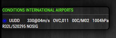
the format on that image is:
Wind direction @ wind speed: 220@05kt
Visibility: 10SM 10 statute miles
Sky Coverage: OVC - overcast, BKN - broken etc…
Cloud base: 150(00)ft
Temp: 10 degrees C
Dewpoint: -1 degrees C
Time of the report in 24 hour clock: 20:51I’d say (personal opinion) that the pressure/altimeter setting isn’t that important. I’d prefer to keep the additional information, if you look at FDY and TBR above, they have:
-RA which is showers of rain
BR - which is fog (or haze, I can’t remember… 70% sure it’s fog, either way you can’t see through it well)That to me is more important that the altimeter setting.
I can look for other examples if that would help?
-
@stephenmelody said in MMM-aviationwx (Aviation weather):
I can look for other examples if that would help?
Nope, that’s good for now
-
How would I denote visibility if this is the data ?
Visibility:1500Simply
1500?v1500? vis? other? -
Do you have an example airport you’re getting that from? Is it outside of the US where viz is usually XXSM?
-
-
@stephenmelody said in MMM-aviationwx (Aviation weather):
Is it outside of the US where viz is usually XXSM?
I thought that was the whole idea for this module, that it would be international, yes?
-
Russian Viz is in metres, so they’d want to see 1500m I’m guessing.
That’s the problem, you’re creating the ability to call weather from international airports but each country / region reports differently. The good thing with AVWX is it tells you the unit to use, so you could just append after the value the unit identifier, so in your example you have:
"Visibility": "9999",and in the units section:
"Visibility": "m",so you could concatenate it to be:
visibility: 9999mDoes that make sense? Have I answered the question?
-
The three main differences I know of are:
USA reports altimeter in inHg, rest of the world is hPa (or mb, which is the same thing).
USA Reports viz in Statute Miles, rest of the world in Kilometers
Russia reports wind speeds in Metres/Second, rest of the world in Knots. (they also report altitude in meters above the ground and the rest of the world uses feet above the ground (or sea level, that also depends…)
That’s when flying becomes fun, so in the UK, you fly at an altitude in feet, a speed in knots (nautical miles per hour) and with a visibility in kilometers… talk about mixing up units!!!
-
@stephenmelody said in MMM-aviationwx (Aviation weather):
Does that make sense? Have I answered the question?
Yup, I’m on it
Hello! It looks like you're interested in this conversation, but you don't have an account yet.
Getting fed up of having to scroll through the same posts each visit? When you register for an account, you'll always come back to exactly where you were before, and choose to be notified of new replies (either via email, or push notification). You'll also be able to save bookmarks and upvote posts to show your appreciation to other community members.
With your input, this post could be even better 💗
Register Login